


Polaris GPS Navigation
Navikey
Opis Polaris GPS Navigation
Zmień swój telefon w potężny system nawigacji GPS z Polaris Navigation GPS, najdokładniejszym uniwersalnym GPS i odważ się iść tam, gdzie nie ma dróg.
Wyobraź sobie... Jak by to było poruszać się po dowolnej drodze wodnej, wędrować po bezdrożach lub mieście, korzystając tylko z funkcji lokalizacyjnych GPS telefonu i widoku nieba? Jak by to było tworzyć cele nawigacji bez konieczności połączenia z Internetem i znajdować je za pomocą map offline lub strzałki wskazującej punkt trasy.
To tylko przebłysk mocy nawigacyjnej, którą będziesz mieć w swoich rękach po zainstalowaniu Polaris Navigation GPS.
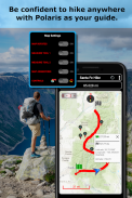
Używany głównie jako aplikacja GPS do wędrówek, jazdy terenowej, żeglarstwa i szlaków, Polaris jest doskonałą kopią zapasową lub zamiennikiem dedykowanej jednostki nawigacji satelitarnej GPS i zapewnia orientację wszędzie tam, gdzie zaprowadzą Cię przygody na świeżym powietrzu!
Typowe użycie:
● Nawigacja po punktach trasy.
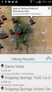
● Turystyka GPS z najlepszymi mapami turystycznymi! Wyszukiwanie i znajdowanie pobliskich szlaków.
● Eksploracja kraju i przygoda na świeżym powietrzu.
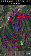
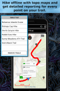
● Nagrywaj ślady i nawiguj po szlakach.
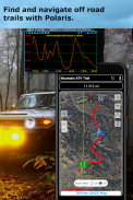
● Obsługa nawigacji terenowej dla Twojego ATV, Jeepa lub innego pojazdu 4x4.
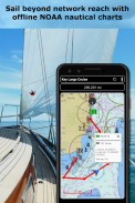
● Żeglarstwo / pływanie łódką. Wszystkie morskie mapy nawigacyjne w Polaris są bezpłatne.
● GPS wędkarski. Z łatwością znajdź swoje ulubione miejsce do wędkowania.
● Polowanie i mapy myśliwskie. Znajdź swoją ulubioną ślepotę myśliwską i drogę powrotną!
● Geocache
● Kemping
● Kolarstwo górskie i mapy rowerowe
● Wędrówki z plecakiem i inne sporty na świeżym powietrzu
● Biegi na orientację z kompasem
Znany ze swojej
, Polaris jest używany przez służby poszukiwawczo-ratownicze na lądzie i morzu, personel wojskowy i miliony innych osób na całym świecie.
📡
📡 Zawiera mapy morskie offline dla USA (ENC i raster).
Ten potężny system nawigacji obejmuje również:
📡 Selektor miejsc polarnych. Znajdź szlaki turystyczne, miejsca kempingowe i wiele więcej!
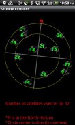
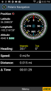
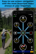
📡 Kompas GPS i kompas magnetyczny.
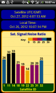
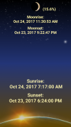
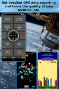
📡 Panel informacyjny GPS.
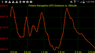
📡 Liczniki, wysokościomierze, prędkościomierze, chronometry.
📡 Dziel dystanse na torach.
📡 Połącz swoje punkty trasy i nawiguj po wyznaczonej przez nie trasie.
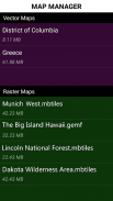
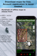
Typy map:
- Mapy Google
- OpenStreetMap-Mapnik
- Mapy topograficzne
- Trasa rowerowa i mapy turystyczne
- Mapy wektorowe
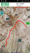
- USGS Topo
- Mapy morskie NOAA
- Wykresy operacji lotniczych
- Kanada Toporama
📡 Kompleksowy zestaw narzędzi GPS i diagnostyki.
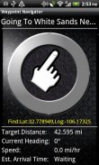
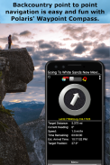
📡 System nawigacji po punktach trasy, w tym dynamiczny kompas do wyszukiwania punktów, który zawsze wskazuje miejsce docelowe, jednocześnie zgłaszając szacowany czas przybycia, odległość do celu i inne statystyki. Po prostu podążaj za strzałką!
📡 System nawigacji po szlakach
📡 Profile wysokości
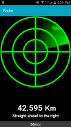
📡 Udostępnianie lokalizacji
📡 Obsługuje brytyjski OSGR i OSGB-36 DATUM (Ordnance Survey Grid).
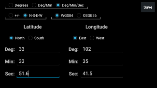
📡 Formaty współrzędnych: szerokość/długość geograficzna w stopniach, deg:min, deg:min:sec i UTM (Universal Transverse Mercator)
📡 Wyszukiwarka współrzędnych wojskowych - wojskowy system odniesienia za pomocą współrzędnych (MGRS)
📡 Szlaki turystyczne - Większość map pokazuje szlaki turystyczne dzięki uprzejmości projektu Openstreetmap. Przekonasz się, że nawet niektóre z najbardziej odległych szlaków turystycznych są widoczne na naszych mapach.
⚓ Nawigacja morska - mapy morskie NOAA i raportowanie jednostek morskich.
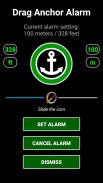
⚓ Alarm dryfu / alarm kotwicy przeciągnij.
📡 Wybierz źródło do raportowania wysokości: Satelity, United States Geologic Survey lub mapuj swoją lokalizację na podstawie wyników misji wahadłowca kosmicznego Radar Topography Mission NASA.
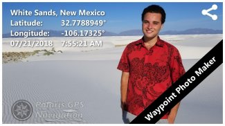
📡 Zdjęcia punktów trasy ze współrzędnymi.
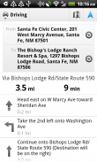
📡 Nawigacja po drogach i wskazówki dojazdu do ulic są dostarczane za pośrednictwem cyfrowego potoku łączącego moc Polaris z aplikacją Mapy Google na Twoim urządzeniu.
.
Polaris GPS Navigation - Wersja 9.25
(30-01-2024)
Polaris GPS Navigation - Informacje APK
Wersja APK: 9.25Pakiet: com.discipleskies.android.polarisnavigationNajnowsza wersja Polaris GPS Navigation
Inne wersje


Apki w tej samej kategorii

Mogą Cię się spodobać...


